-Faulting
-Crustal warping
(b)
-Lake Kenyatta is an example of a human made v lake.
-A dam was built across river Tana.
-The dam formed a barrier across a river hence blocking water from flowing downstream.
-Water accumulated upstream behind the dam.
-This resulted on a large mass of water occupying a depression behind the dam which was named lake Kenyatta.
steve williams answered the question on December 27, 2017 at 21:41
-
Name two main towns in the cocoa triangle in Ghana
(Solved)
Name two main towns in the cocoa triangle in Ghana.
Date posted:
December 22, 2017
.
Answers (1)
-
Give four reasons why Norway is a great fishing nation
(Solved)
Give four reasons why Norway is a great fishing nation.
Date posted:
December 15, 2017
.
Answers (1)
-
Differentiate between snout and snow niche
(Solved)
Differentiate between snout and snow niche.
Date posted:
December 15, 2017
.
Answers (1)
-
Name four secondary products of forests
(Solved)
Name four secondary products of forests.
Date posted:
December 15, 2017
.
Answers (1)
-
What is the significance of statistics in geography?
(Solved)
What is the significance of statistics in geography?
Date posted:
December 15, 2017
.
Answers (1)
-
State the characteristics of winter solstice
(Solved)
State the characteristics of winter solstice.
Date posted:
December 15, 2017
.
Answers (1)
-
Why is fishing more developed in northern hemisphere than southern hemisphere?
(Solved)
Why is fishing more developed in northern hemisphere than southern hemisphere?
Date posted:
December 15, 2017
.
Answers (1)
-
What are the differences between aridity and desertification?
(Solved)
What are the differences between aridity and desertification?
Date posted:
December 8, 2017
.
Answers (1)
-
Explain four ways in which vegetation in the Nyika region of Kenya has adapted to the climate conditions experienced in the area
(Solved)
Explain four ways in which vegetation in the Nyika region of Kenya has adapted to the climate conditions experienced in the area.
Date posted:
December 7, 2017
.
Answers (1)
-
Why are African rivers not effective for transportation?
(Solved)
Why are African rivers not effective for transportation?
Date posted:
December 6, 2017
.
Answers (1)
-
Explain the differences between mudflows and earthflows.
(Solved)
Explain the differences between mudflows and earthflows.
Date posted:
December 3, 2017
.
Answers (1)
-
Give three examples of inselbergs in East Africa
(Solved)
Give three examples of inselbergs in East Africa.
Date posted:
November 28, 2017
.
Answers (1)
-
Explain four negative influence of vulcanicity on the physical and human environment.
(Solved)
Explain four negative influence of vulcanicity on the physical and human environment.
Date posted:
November 24, 2017
.
Answers (1)
-
State three ways in which a caldera may be formed.
(Solved)
State three ways in which a caldera may be formed.
Date posted:
November 24, 2017
.
Answers (1)
-
(a) List two theories which explain the formation of Fold Mountains.
(b) A part from Fold Mountains, name three other features which result from folding.
(Solved)
(a) List two theories which explain the formation of Fold Mountains.
(b) A part from Fold Mountains, name three other features which result from folding.
Date posted:
November 24, 2017
.
Answers (1)
-
Use the map below to answer the question that follow
(Solved)
Use the map below to answer the question that follow
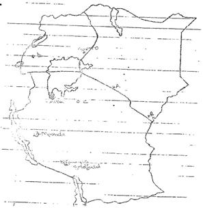
(i)Name the minerals mined in areas marked A and D
(ii)State three economic benefits of mining of the mineral in region A
(iii)List two uses of the mineral mined in region A
Date posted:
November 21, 2017
.
Answers (1)
-
Give the similarities of fishing in Kenya and Japan
(Solved)
Give the similarities of fishing in Kenya and Japan
Date posted:
November 21, 2017
.
Answers (1)
-
Give the differences between softwood in Kenya and Canada
(Solved)
Give the differences between softwood in Kenya and Canada
Date posted:
November 21, 2017
.
Answers (1)
-
The diagram below represents a sketch map of the Great lakes and St. Lawrence seaway.Use it to answer the questions below.
(Solved)
The diagram below represents a sketch map of the Great lakes and St. Lawrence seaway.Use it to answer the questions below.
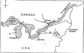
Name (i)canals marked N and Q
(ii)The lakes marked O
(iii)The ports marked M
Date posted:
November 20, 2017
.
Answers (1)
-
The diagram below represents underground features in limestone area.use it to answer questions that follow.
(Solved)
The diagram below represents underground features in limestone area.use it to answer questions that follow.
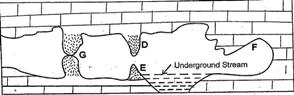
(i)Name the features marked D,E and F
(ii)Describe how feature marked G is formed.
Date posted:
November 20, 2017
.
Answers (1)