-
With the aid of well labeled diagrams describe how a limestone pillar is formed.
Date posted:
November 17, 2022
-
Suppose you were to carry out a field study of rocks within your school vicinity.
i) Name three secondary sources of information you would use to prepare for the field study.
ii) State three activities you would carry out during the field study.
Date posted:
November 17, 2022
-
Supposing you were to carry out a field study on the Rift Valley.
(i) State any two objectives of the study.
(ii) State three importance of studying faulting through field work.
(iii) Explain the significance of faulting to human activities.
Date posted:
November 17, 2022
-
With the help of a diagram explain the formation of the rift valley through the tension process.
Date posted:
November 17, 2022
-
Use the map of Africa below to answer the following questions.
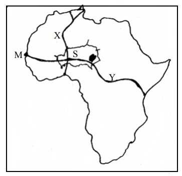 (i) Name the highways marked X and Y.
(ii) Name the port marked M.
(iii) Name the country marked S.
(i) Name the highways marked X and Y.
(ii) Name the port marked M.
(iii) Name the country marked S.
Date posted:
November 17, 2022
-
Compare forestry in Kenya and Canada under the following headings:-
(i) Transportation of the logs.
(ii) Felling of trees.
(iii) Tree species.
Date posted:
November 15, 2022
-
Explain three problems which hinder the Kenya government’s effort to manage and conserve her forests.
Date posted:
November 15, 2022
-
The table below gives the figures for the 2009 population census per county for the central region of Kenya.
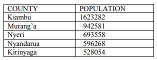 (a) (i) Besides bar graphs, name three other methods that can be used to represent the above data.
(ii) Draw a simple bar graph to represent the data in the table above.
Use a scale of 1cm to represent 200,000 persons.
(iii) State four advantages of using bar graphs to represent statistical data.
(b) Calculate the population density for Kiambu County, given that its area is 2543.4 square kilometers.
(c) Give two reasons why census is necessary.
(d) Explain four reasons for the high population density in Kiambu County.
(a) (i) Besides bar graphs, name three other methods that can be used to represent the above data.
(ii) Draw a simple bar graph to represent the data in the table above.
Use a scale of 1cm to represent 200,000 persons.
(iii) State four advantages of using bar graphs to represent statistical data.
(b) Calculate the population density for Kiambu County, given that its area is 2543.4 square kilometers.
(c) Give two reasons why census is necessary.
(d) Explain four reasons for the high population density in Kiambu County.
Date posted:
November 15, 2022
-
State three reasons for reclaiming swamps in Kenya
Date posted:
November 15, 2022
-
Name two main reclamation projects in the Netherlands.
Date posted:
November 14, 2022
-
Describe how laterisation occurs.
Date posted:
November 14, 2022
-
Explain how the following factors influence the soil formation.
(i) Climate.
(ii) Topography.
Date posted:
November 14, 2022
-
Define term soil conservation.
Date posted:
November 14, 2022
-
You intend to carry out a field study in an arid area near your school.
(i) State two reasons for carrying out a pre-visit.
(ii) Apart from Barchan state three depositional features they are likely to have identified.
(iii) State four positive effects of deserts features to man that you are likely to identify.
Date posted:
November 14, 2022
-
You are supposed to carry out a field study in an area affected by faulting.
(i) Apart from the Rift Valley name three other features that you are likely to identify.
(ii) State two methods you will use to collect data.
(iii) Explain three economic benefits of faulting they are likely to identify.
Date posted:
November 14, 2022
-
Students from Buma School carried a field study on rocks in their county.
(i) State three reasons why it would be necessary for them to conduct a reconnaissance to the study area.
(ii) Give two methods they used to record data.
(iii)State three importance of rocks they identified.
Date posted:
November 14, 2022
-
Give two reasons why sedimentary rocks are dominant along the Kenyan Coast.
Date posted:
November 14, 2022
-
State three changes that occur in rocks during metamorphism.
Date posted:
November 14, 2022
-
Describe how sedimentary rocks are formed through physical processes
Date posted:
November 14, 2022
-
State three effects of climate change.
Date posted:
November 14, 2022
-
The diagram below show the formation of some type of rainfall.
Use it to answer question (a) and (b).
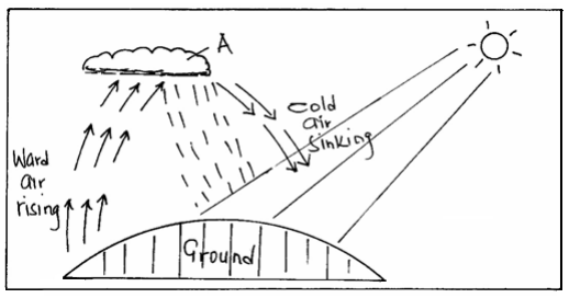 (a) (i) Name the type of rainfall shown by this diagram.
(ii) Name the type of cloud marked (A).
(b) List three weather conditions associated with the above name (a) type of rainfall.
(a) (i) Name the type of rainfall shown by this diagram.
(ii) Name the type of cloud marked (A).
(b) List three weather conditions associated with the above name (a) type of rainfall.
Date posted:
November 14, 2022
-
(i) Students from Nairobi visited Mt. Kenya forest. State two reasons why they needed a route map.
(ii) Explain two ways of how the students’ findings would assist the local people of
the area.
Date posted:
November 19, 2019
-
Explain three ways of how forests regulate local climate.
Date posted:
November 19, 2019
-
Explain four problems the Kenya Government is facing in conserving wildlife.
Date posted:
November 19, 2019
-
Compare coffee farming in Kenya and Brazil under the following sub-heading:
(i) Growing area.
(ii) labour
Date posted:
November 19, 2019
-
Study the graph below showing Kenya’s leading export crops by value from 1997 to 2001 and answer the questions that follow.
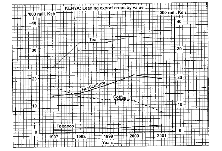 a. i) Name the technique represented in the above graph.
ii) State two disadvantages of the above technique.
b. i) Which crop, had the highest change in value between 1997 and 2001.
ii) Calculate the percent change in b.(i).
a. i) Name the technique represented in the above graph.
ii) State two disadvantages of the above technique.
b. i) Which crop, had the highest change in value between 1997 and 2001.
ii) Calculate the percent change in b.(i).
Date posted:
November 19, 2019
-
Explain the importance of soil organisms in soil development.
Date posted:
November 19, 2019
-
State three characteristics of chernozem soils.
Date posted:
November 19, 2019
-
You carried out a field study on rocks within the school vicinity.
i) State three objectives of your study.
ii) Identify two equipment/tools you used during data collection.
iii) Give three reasons why you used fieldwork in studying rocks.
Date posted:
November 19, 2019
-
Use the diagram below to answer the question that follows.
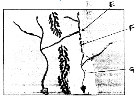 i) What is the process shown above?
ii) Identify the features marked E, F and G.
iii) State three conditions necessary for the development of the above feature.
i) What is the process shown above?
ii) Identify the features marked E, F and G.
iii) State three conditions necessary for the development of the above feature.
Date posted:
November 19, 2019