- The soils are highly desalinized.
- They are protected by dykes against gales/sea encroachments.
- They are surrounded by Ring Canals to facilitate drainage.
- They are divided into specific land use activities.
- The land is intensively utilised.
- Horticulture is the predominant agricultural activity.
- They are large in acreage/area/size.
- They are relatively flat.
- They are largely flat.
- They are largely below the sea level.
Kavungya answered the question on May 30, 2019 at 09:21
-
Explain three reasons why some rift valley lakes are drying up.
(Solved)
Explain three reasons why some rift valley lakes are drying up.
Date posted:
May 30, 2019
.
Answers (1)
-
Give three reasons why cloud concentration is higher in the troposphere.
(Solved)
Give three reasons why cloud concentration is higher in the troposphere.
Date posted:
May 30, 2019
.
Answers (1)
-
Explain five problems facing commercial maize cultivation in the Rift valley Region of Kenya.
(Solved)
Explain five problems facing commercial maize cultivation in the Rift valley Region of Kenya.
Date posted:
May 30, 2019
.
Answers (1)
-
Describe basket fishing as a method of fishing in Kenya.
(Solved)
Describe basket fishing as a method of fishing in Kenya.
Date posted:
May 30, 2019
.
Answers (1)
-
Give two characteristics of derelict land in connection with commercial mining.
(Solved)
Give two characteristics of derelict land in connection with commercial mining.
Date posted:
May 30, 2019
.
Answers (1)
-
Identify the dominant types rock of rocks in the following regions of Kenya
i) Coastal Kenya
ii) Eastern Kenya
iii) Western Kenya
(Solved)
Identify the dominant types rock of rocks in the following regions of Kenya
i) Coastal Kenya
ii) Eastern Kenya
iii) Western Kenya
Date posted:
May 30, 2019
.
Answers (1)
-
Give the differences in the exploitation of softwood forests in Kenya and Canada under the following sub-headings:
i) Period of harvesting.
ii) Transportation
(Solved)
Give the differences in the exploitation of softwood forests in Kenya and Canada under the following sub-headings:
i) Period of harvesting.
ii) Transportation
Date posted:
May 30, 2019
.
Answers (1)
-
The diagram below show the occurrence of petroleum in the earth's crust. Use it to answer question below
Name the substances in the areas labelled L,...
(Solved)
The diagram below show the occurrence of petroleum in the earth's crust. Use it to answer question below
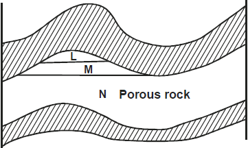
Name the substances in the areas labelled L, M and N.
Date posted:
May 30, 2019
.
Answers (1)
-
Give two main reasons why convectional rainfall is common in Western Kenya region.
(Solved)
Give two main reasons why convectional rainfall is common in Western Kenya region.
Date posted:
May 30, 2019
.
Answers (1)
-
State the uniqueness of Geography as compared to other subjects.
(Solved)
State the uniqueness of Geography as compared to other subjects.
Date posted:
May 30, 2019
.
Answers (1)
-
Draw a sketch map of Ghana.
On the sketch map mark and label.
i) Accra
ii) Cocoa growing areas.
iii) Name two varieties of cocoa grown...
(Solved)
Draw a sketch map of Ghana.
On the sketch map mark and label.
i) Accra
ii) Cocoa growing areas.
iii) Name two varieties of cocoa grown in Ghana
Date posted:
May 30, 2019
.
Answers (1)
-
The table below shows the number of tourists who visited National Parks and Game Reserves in Kenya between 2007 and 2008. Use it to answer...
(Solved)
The table below shows the number of tourists who visited National Parks and Game Reserves in Kenya between 2007 and 2008. Use it to answer questions below.
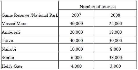
i) Draw a divided rectangle 15cm long to represent tourists who visited Kenya in 2007.
ii) Which Game Reserve / National park had the highest decline in the number of tourists in 2008?
iii) Calculate the total number of tourists who visited Kenya for the two years.
Date posted:
May 30, 2019
.
Answers (1)
-
With the aid of a clearly labeled diagram, describe the occurrence of katabatic winds.
(Solved)
With the aid of a clearly labeled diagram, describe the occurrence of katabatic winds.
Date posted:
May 29, 2019
.
Answers (1)
-
State two ways in which geographers study the interior of the earth.
(Solved)
State two ways in which geographers study the interior of the earth.
Date posted:
May 29, 2019
.
Answers (1)
-
The map of African below shows hydroelectric power projects. Use it to answer questions that follow.
Name the hydroelectric power projects marked A, B, C and...
(Solved)
The map of African below shows hydroelectric power projects. Use it to answer questions that follow.
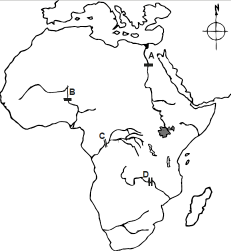
Name the hydroelectric power projects marked A, B, C and D.
Date posted:
May 29, 2019
.
Answers (1)
-
Name two ways in which underground water reaches the surface.
(Solved)
Name two ways in which underground water reaches the surface.
Date posted:
May 29, 2019
.
Answers (1)
-
State four factors that influenced the location of Olkaria Geothermal Unit.
(Solved)
State four factors that influenced the location of Olkaria Geothermal Unit.
Date posted:
May 29, 2019
.
Answers (1)
-
What is a river divide?
(Solved)
What is a river divide?
Date posted:
May 29, 2019
.
Answers (1)
-
Name the type of delta found at the mouth of
i) River Nile
ii) River Omo.
(Solved)
Name the type of delta found at the mouth of
i) River Nile
ii) River Omo.
Date posted:
May 29, 2019
.
Answers (1)
-
Explain three reasons why Kenya import sugar yet she is a producer of the same commodity.
(Solved)
Explain three reasons why Kenya import sugar yet she is a producer of the same commodity.
Date posted:
May 29, 2019
.
Answers (1)