
Raw Materials
- Industries are located near sources of raw materials to reduce transportation costs e.g. sugar milling factories in sugar growing areas, mostly in urban areas near airports and oil refineries at the coast since oil is bulky and expensive to transport inland
- They are also established where there is a steady source of raw materials in order for them to be economically viable e.g. oil refineries at the coast
Power
- They are located near main power supply pints to reduce the cost of transmitting power e.g. those in Jinja town near Owen falls dam.
Transport and Communication
- They are located where transportation system is well established to ensure efficient and quick transportation of raw materials to industries and finished goods to the market e.g. in urban centres.
- They are located where there is efficient communication so as to stay in touch with their suppliers and their consumers.
- Well developed communication systems also lower the transport cost.
Market
- They are located where buyers of products are available or in areas with dense population to make their operation to be economically viable since they are established for commercial purpose to make a profit e.g. in urban areas, Kenya highlands, lake region and coastal strip.
Location near markets is also due to the nature of goods e.g. perishable goods have to be consumed before they go bad e.g. bread and daily products. Industries making fragile goods are located near markets to prevent the high risk of breakage during transportation e.g. glass, bricks and roofing tiles.
Labour
- Labour intensive industries are located in densely populated areas where there is adequate and cheap labour to reduce production costs.
- Also so as to reduce the cost of transporting and housing workers.
- A country with skilled manpower has faster industrial growth than that without which are forced to depend on expatriates who are costly to hire and maintain which lowers the profits of such industries
Industries also require skilled manpower and management skills to ensure maximum output and low production costs.
Water Supply
- Some are located near sources of water such as large permanent rivers and lakes to provide water for processing raw materials e.g. coffee pulping, sugar milling e.g. Mumias near R. Nzoia, Sony near R. Migori and Chemilil near R. Nyando.
Government Policies
- Decentralisation of industries
or encouraging by providing incentives location of industries from urban to rural areas.
Incentives
1. Tax exemptions
2. Protection from foreign competition.
gideon1 answered the question on October 4, 2017 at 04:55
-
The diagram below represent feature produced by faulting . use it to answer Question
(Solved)
The diagram below represent feature produced by faulting . use it to answer Question
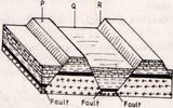
a) Name the feature marked p , Q and R
b)Differentiate between a normal fault and reverse fault
Date posted:
October 3, 2017
.
Answers (1)
-
The map below shows the location of some mountain ranges.
(Solved)
The map below shows the location of some mountain ranges.
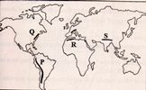
a) Name the ranges marked P ,Q , R and S
B. i) Apart from Fold mountains , name three other features resulting from folding
II) With the aid of labelled diagrams , describe how fold mountain are formed
C) Explain the significance of Fold mountains to human activities
Date posted:
October 3, 2017
.
Answers (1)
-
The map below shows the location of some mountain ranges.
(Solved)
The map below shows the location of some mountain ranges.
a) Name the ranges marked P ,Q , R and S
B. i) Apart from Fold mountains , name three other features resulting from folding
II) With the aid of labelled diagrams , describe how fold mountain are formed
C) Explain the significance of Fold mountains to human activities
Date posted:
October 3, 2017
.
Answers (1)
-
The diagram below shows some types of folds. Use it to answer question
(Solved)
The diagram below shows some types of folds. Use it to answer question
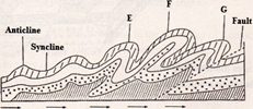
a) Name the types of fold marked E, F and G
b) In which counties are the following fold mountain found?
(i) Andes
(ii) Cape Range
(iii) Alps
Date posted:
October 3, 2017
.
Answers (1)
-
The diagram below represent the structure of the atmosphere . use it to answer question
(Solved)
The diagram below represent the structure of the atmosphere . use it to answer question
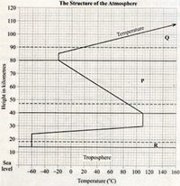
(a) Name : (I) the parts marked p and Q
(ii) The layer of discontinuity marked R
(b) state two characteristics of the weather condition in the atmosphere.
Date posted:
October 3, 2017
.
Answers (1)
-
State characteristics of equatorial rain forest.
(Solved)
State characteristics of equatorial rain forest.
Date posted:
October 2, 2017
.
Answers (1)
-
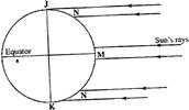
The diagram below shows the angles of the sun's rays at different latitudes when the sun is at the equator. Use it to answer question...
(Solved)
The diagram below shows the angles of the sun's rays at different latitudes when the sun is at the equator. Use it to answer question (a) and (b).
Date posted:
September 30, 2017
.
Answers (1)
-
Give two reasons why it is difficult to transport goods from Mombasa to Lagos by road.
(Solved)
Give two reasons why it is difficult to transport goods from Mombasa to Lagos by road.
Date posted:
September 30, 2017
.
Answers (1)
-
Explain four advantages of rail transport over road transport.
(Solved)
Explain four advantages of rail transport over road transport.
Date posted:
September 30, 2017
.
Answers (1)
-
State two problems facing communication in Kenya.
(Solved)
State two problems facing communication in Kenya.
Date posted:
September 30, 2017
.
Answers (1)
-
Give three ways in which cell phones contribute to Kenya’s economic development.
(Solved)
Give three ways in which cell phones contribute to Kenya’s economic development.
Date posted:
September 30, 2017
.
Answers (1)
-
Name three main modes of transport in Kenya.
(Solved)
Name three main modes of transport in Kenya.
Date posted:
September 30, 2017
.
Answers (1)
-
Give three measures used to conserve forests in Kenya.
(Solved)
Give three measures used to conserve forests in Kenya.
Date posted:
September 30, 2017
.
Answers (1)
-
State three factors favouring the development of softwood forests in Canada.
(Solved)
State three factors favouring the development of softwood forests in Canada.
Date posted:
September 30, 2017
.
Answers (1)
-
Compare forestry in Kenya and Canada under the following subheadings:
i)Distribution of forests.
ii)Mode of exploitation
iii) Transport
(Solved)
Compare forestry in Kenya and Canada under the following subheadings:
i)Distribution of forests.
ii)Mode of exploitation
iii) Transport
Date posted:
September 30, 2017
.
Answers (1)
-
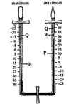
The diagram below shows a six's Thermometer. Name the parts marked P, Q and R.
(Solved)
The diagram below shows a six's Thermometer. Name the parts marked P, Q and R.
Date posted:
September 30, 2017
.
Answers (1)
-
Explain three factors that favour the growth of natural forests on the slopes of Mt. Kenya.
(Solved)
Explain three factors that favour the growth of natural forests on the slopes of Mt. Kenya.
Date posted:
September 30, 2017
.
Answers (1)
-
State three factors that lead to depletion of forests in Kenya.
(Solved)
State three factors that lead to depletion of forests in Kenya.
Date posted:
September 30, 2017
.
Answers (1)
-
Explain the physical factors favouring tourism in Switzerland.
(Solved)
Explain three physical factors favouring tourism in Switzerland.
Date posted:
September 30, 2017
.
Answers (1)
-
Give two reasons why domestic tourism is encouraged in Kenya.
(Solved)
Give two reasons why domestic tourism is encouraged in Kenya.
Date posted:
September 30, 2017
.
Answers (1)