i)
X - North East Atlantic
Y - North West Pacific
ii)
- Indented coastline provide secure fish breeding grounds because the boys sheltered from sea waves.
- Has several fiords suitable for the building of fishing ports/fish landing sites.
- The warm North Pacific current makes the water ice free therefore fishing is carried out throughout the year.
- Rugged landscape adjacent to the coast discourage agriculture therefore people resort to fishing as an alternative economic activity.
- The ocean currents of warm and cold meeting causes up welling of water which bring minerals to the surface for the planktons which are fish food.
marto answered the question on September 26, 2019 at 08:44
-
Form four students in your school carried a field study on Thika town.
(i). Give four factors that led to growth of Thika as an industrial...
(Solved)
Form four students in your school carried a field study on Thika town.
(i). Give four factors that led to growth of Thika as an industrial centre.
(ii). Give four advantages of studying industry through field work
Date posted:
September 26, 2019
.
Answers (1)
-
State four physical factors that favored the establishment of Ruhr Industrial region in Germany.
(Solved)
State four physical factors that favored the establishment of Ruhr Industrial region in Germany.
Date posted:
September 26, 2019
.
Answers (1)
-
Explain three ways in which the government of Kenya can assist maize farmers in Kenya.
(Solved)
Explain three ways in which the government of Kenya can assist maize farmers in Kenya.
Date posted:
September 26, 2019
.
Answers (1)
-
The table below shows maize production in Kenya per county; between 2017 – 2018 in `000 kgs
(Solved)
The table below shows maize production in Kenya per county; between 2017 – 2018 in `000 kgs
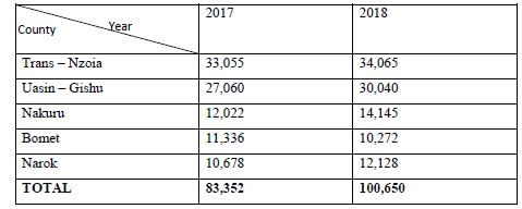
(i). Using a scale of 1cm to represent 10 million kgs, draw a divided rectangle to represent the data for maize production in 2018.
(ii). Describe the production of maize in the 5 counties in Kenya.
Date posted:
September 26, 2019
.
Answers (1)
-
Give two measures of conservation energy.
(Solved)
Give two measures of conservation energy.
Date posted:
September 26, 2019
.
Answers (1)
-
State three conditions necessary for the formation of ice.
(Solved)
State three conditions necessary for the formation of ice.
Date posted:
September 26, 2019
.
Answers (1)
-
Define the term Moraine.
(Solved)
Define the term Moraine.
Date posted:
September 26, 2019
.
Answers (1)
-
With the aid of a well-labelled diagram, describe the formation of cyclonic rainfall.
(Solved)
With the aid of a well-labelled diagram, describe the formation of cyclonic rainfall.
Date posted:
September 26, 2019
.
Answers (1)
-
The table below shows climatic figure for station Q. Use it to answer the questions that follow.
(Solved)
The table below shows climatic figure for station Q. Use it to answer the questions that follow.
(i) Calculate the annual range of temperature for station Q.
(ii) Give four characteristics of climate for station Q.
Date posted:
September 26, 2019
.
Answers (1)
-
The diagram below shows a weather measuring instrument. Use it to answer the questions below.
(Solved)
The diagram below shows a weather measuring instrument. Use it to answer the questions below.
(i) Name the parts marked M and N.
(ii) Describe how the instrument works
Date posted:
September 26, 2019
.
Answers (1)
-
Study the map of Taita hills, 1:50,000 sheet provided and answer the question that follow.
(a) (i) What is the latitudinal and longitudinal extent of Taita...
(Solved)
Study the map of Taita hills, 1:50,000 sheet provided and answer the question that follow.
(a) (i) What is the latitudinal and longitudinal extent of Taita Hills map extract?
(ii) Convert the ratio scale of the map into statement.
(b) Citing evidence from the map, identify four social activities in the area covered by Taita Hills.
(c) (i) Draw a rectangle 20cm by 16cm from Easting 32 to 37 Northings 14 to 18.
(ii) On the rectangle mark and name;
- Taita sisal estate
- Hills
- Main track/motorable
- River
(iii) Calculate the new scale of the drawn rectangle
(d) Citing evidence, explain three ways how relief has influenced the distribution of settlement in Taita Hills.
(e) Describe the vegetation in the area covered by the map.
Date posted:
September 26, 2019
.
Answers (1)
-
The diagram below shows the hydrological cycle. Study and use it to answer the question that follows
(Solved)
The diagram below shows the hydrological cycle. Study and use it to answer the question that follows.
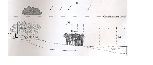
(a) Identify the processes marked K and L.
(b) State three characteristics of a flood plain.
Date posted:
September 26, 2019
.
Answers (1)
-
List two disadvantages of small scale farming.
(Solved)
List two disadvantages of small scale farming.
Date posted:
September 12, 2019
.
Answers (1)
-
Using well labeled diagrams, explain how each of the following features are formed.
i) Spit
ii) Blow hole
(Solved)
Using well labeled diagrams, explain how each of the following features are formed.
i) Spit
ii) Blow hole
Date posted:
September 12, 2019
.
Answers (1)
-
List three processes through which coasts are eroded.
(Solved)
List three processes through which coasts are eroded.
Date posted:
September 12, 2019
.
Answers (1)
-
Name three places in East Africa where glaciers are found.
(Solved)
Name three places in East Africa where glaciers are found.
Date posted:
September 12, 2019
.
Answers (1)
-
Explain how the following factors influence climate.
i) Latitude
ii) Altitude
iii) Aspect
iv) Winds
(Solved)
Explain how the following factors influence climate.
i) Latitude
ii) Altitude
iii) Aspect
iv) Winds
Date posted:
September 12, 2019
.
Answers (1)
-
You intend to carry out a field study of the land forms around your school.
i) State three objectives of your study.
ii) State three methods...
(Solved)
You intend to carry out a field study of the land forms around your school.
i) State three objectives of your study.
ii) State three methods you would use to record the information you would collect
Date posted:
September 12, 2019
.
Answers (1)
-
Give the two dates of equinoxes.
(Solved)
Give the two dates of equinoxes.
Date posted:
September 12, 2019
.
Answers (1)
-
List four characteristics of desert soils.
(Solved)
List four characteristics of desert soils.
Date posted:
September 12, 2019
.
Answers (1)