(a)
(i) What is the latitudinal and longitudinal extent of Taita Hills map extract?
- Latitudinal extent is from 3014' South t 3030' South.
-Longitudinal extent is from 38016' East to 38030' East.
(ii) Convert the ratio scale of the map into statement.
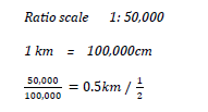
Statement scale 1 cm represents 0.5km / ½ km
1cm represents ½ km
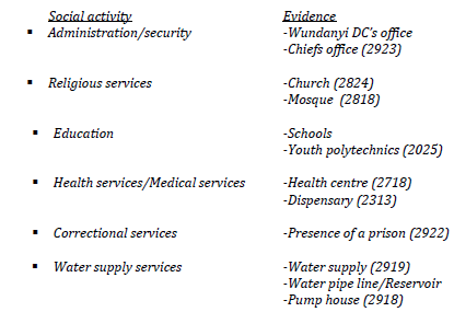
(b) Citing evidence from the map, identify four social activities in the area covered by Taita Hills.
c)
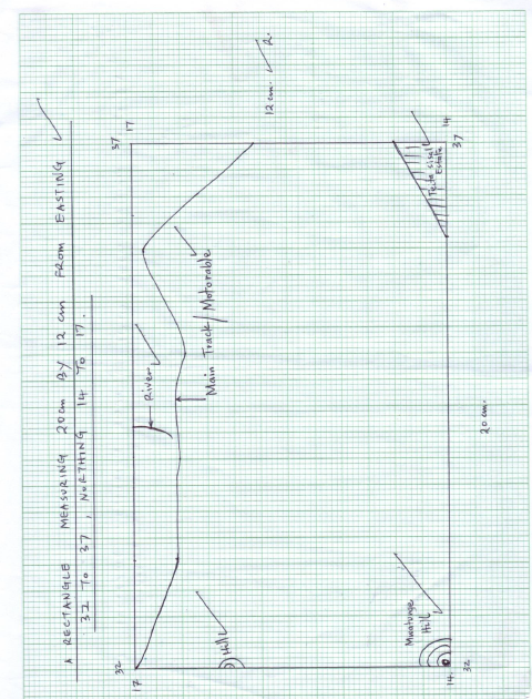
(ii) On the rectangle mark and name;
- Taita sisal estate
- Hills
- Main track/motorable
- River
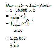
(iii) Calculate the new scale of the drawn rectangle.
(d) Citing evidence, explain three ways how relief has influenced the distribution of settlement in Taita Hills.
- Rugged slopes/steep slopes evidenced by closely by closely packed contours in the western part have dense/Many settlement because the area is well drained.
- Gentle slopes evidenced by widely spaced contours in the eastern part have few settlement since the area is poorly drained/dry.
- River valleys along the rivers have few settlement since the areas are prone to flooding.
(e) Describe the vegetation in the area covered by the map.
- Forests are found in the western part of the map.
-Thicket vegetation found to the East of the area covered by the map.
-Scrub vegetation is found to the West of the map.
-Some scattered trees are found to the North of he map.
- Some woodland vegetation is found to the South East of the area covered by the map.
marto answered the question on
September 26, 2019 at 07:51