 Get premium membership
 and access questions with answers, video lessons as well as revision papers.
- The population of giraffes in a certain game reserve was 1,500 in one year. In the following year the giraffe population increased by 20%.
The population of giraffes in a certain game reserve was 1,500 in one year. In the following year the giraffe population increased by 20%. What was the number of giraffes in the game reserve after the increase?
A.300
B.1,800
C.1,200
D.1,950
Date posted: March 21, 2019
- The total surface area of an open cylindrical container is 594 cm² . If the diameter of the container is 14 cm, what is its height in centimeters?
The total surface area of an open cylindrical container is 594 cm². If the diameter of the container is 14 cm, what is its height in centimeters?
Take π=227
A.20
B.13.5
C.6.5
D.10
Date posted: March 21, 2019
- What is the value of 3²(5²-4²)-3²4²-2²
What is the value of 3²(5²-4²)-3²4²-2²
A.6
B.3
C.9
D.36
Date posted: March 21, 2019
- What is the value of 13.86 x 6.94 rounded off to two decimal places?
What is the value of 13.86 x 6.94 rounded off to two decimal places?
A.96.18
B.96.188
C.96.2
D.96.19
Date posted: March 21, 2019
- The marked price of a pair of shoes is sh 1 200. A customer was given a 20% discount. How much did he pay for the pair of shoes?
The marked price of a pair of shoes is sh 1 200. A customer was given a 20% discount. How much did he pay for the pair of shoes?
A.sh 1,440
B.sh 240
C.sh 960
D.sh 1,080
Date posted: March 21, 2019
- What is the difference between the LCM and GCD of 12, 18 and 36?
What is the difference between the LCM and GCD of 12, 18 and 36?
A.30
B.36
C.6
D.12
Date posted: March 21, 2019
- The length of the base of a triangle is (3x + 5) cm and its height is 10 cm. If the area of the triangle is 115 cm² , what is the value of x?
The length of the base of a triangle is (3x + 5) cm and its height is 10 cm. If the area of the triangle is 115 cm² , what is the value of x?
A.7
B.6
C.8
D.5
Date posted: March 21, 2019
- Kago had salt in packets as follows:
150 packets of 100g each
120 packets of 250g each
100 packets of 500g each
80 packets of 1kg each
25 packets of 2kg each
He decided to re-pack all this salt in 14kg packets. How many packets did he get?
Kago had salt in packets as follows:
150 packets of 100g each
120 packets of 250g each
100 packets of 500g each
80 packets of 1kg each
25 packets of 2kg each
He decided to re-pack all this salt in 14kg packets. How many packets did he get?
A.900
B.880
C.450
D.500
Date posted: March 21, 2019
- The ratio of men to women in a committee is 3:2. If there are 3 more men than women, how many women are in the committee?
The ratio of men to women in a committee is 3:2. If there are 3 more men than women, how many women are in the committee?
A.6
B.9
C.15
D.5
Date posted: March 21, 2019
- The marked price of a radio is sh 1,800. Waithera bought the radio at a discount of 15%. How much did she pay for the radio?
The marked price of a radio is sh 1,800. Waithera bought the radio at a discount of 15%. How much did she pay for the radio?
A.sh 270
B.sh 2,070
C.sh 1,530
D.sh 1,785
Date posted: March 21, 2019
- Aluoch bought the following items from a supermarket.
Aluoch bought the following items from a supermarket.
2kg of sugar at sh 48 per kilogram
2kg tin of cooking fat for sh 165
2 packets of tea leaves at sh 155 each
3 loaves of bread for sh 63
She paid her bill with a one thousand shilling note. How much change did she get?
A.sh 75
B.sh 240
C.sh 366
D.sh 201
Date posted: March 21, 2019
- In a polling station there were 900 registered voters. During an election 10% of the registered voters did not cast their votes. The rest cast their votes to Ahmed, Babu and Chambuko..
In a polling station there were 900 registered voters. During an election 10% of the registered voters did not cast their votes. The rest cast their votes to Ahmed, Babu and Chambuko in the ratio 3:2:1. If 30 votes were spoilt, how many votes did Ahmed get?
A.405
B.435
C.260
D.390
Date posted: March 21, 2019
- What is the median, mode and mean, in that order, of the following numbers:
20, 22, 19, 26, 44, 15, 37, 40, 25, 23, 26?
What is the median, mode and mean, in that order, of the following numbers:
20, 22, 19, 26, 44, 15, 37, 40, 25, 23, 26?
A.25, 26, 27
B.27, 26, 25
C.25, 27, 26
D.26, 25, 27
Date posted: March 21, 2019
- A school had three streams from standard 1 to standard 4 and two streams from standard 5 to standard 8. In a certain year, the average number of pupils per class was as follows:
A school had three streams from standard 1 to standard 4 and two streams from standard 5 to standard 8. In a certain year, the average number of pupils per class was as follows:
Standard 1 to standard 4: 50
Standard 5 to standard 8: 40
Each pupil in the school was given 6 exercise books. The exercise books were delivered to the school in packets each containing a dozen exercise books. How many packets were delivered in the school?
A.46
B.440
C.480
D.460
Date posted: March 21, 2019
- Ogembo bought a sofa set on hire purchase by paying a deposit of sh 3 600. The balance was to be paid in 8 equal monthly instalments of sh 1 350. The hire purchase price was 20% more than the cash price
Ogembo bought a sofa set on hire purchase by paying a deposit of sh 3 600. The balance was to be paid in 8 equal monthly instalments of sh 1 350. The hire purchase price was 20% more than the cash price. What was the cash price of the sofa set?
A.sh 14,400
B.sh 13,500
C.sh 12,000
D.sh 17,280
Date posted: March 21, 2019
- A cylindrical container has a capacity of 2.31 liters. If the diameter of the container is 14 cm, what is its height of the container in centimeters?
A cylindrical container has a capacity of 2.31 liters. If the diameter of the container is 14 cm, what is its height of the container in centimeters?
Take p=227
A.15
B.3.75
C.10
D.14
Date posted: March 21, 2019
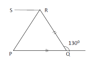
- In the figure below, PQT is a straight line and PQ is parallel to SR. Line PQ=QR and angle
RQT = 130°. What is the size of angle PRS?
In the figure below, PQT is a straight line and PQ is parallel to SR. Line PQ=QR and angle
RQT = 130°. What is the size of angle PRS?
A.45°
B.65°
C.55°
D.35°
Date posted: March 21, 2019
- In one year a businessman made a profit of sh 86,500. In the following year his profits increased by 20%. How much profit did he make that year?
In one year a businessman made a profit of sh 86,500. In the following year his profits increased by 20%. How much profit did he make that year?
A.sh 86,520
B.sh 69,200
C.sh 103,800
D.sh 86,480
Date posted: March 21, 2019
- A certain poultry farm keeps hens, ducks and turkeys. The ratio of hens to ducks is 5 : 2. The number of turkeys is 35 less than the number of hens. If there are 30 ducks, how many turkeys are there?
A certain poultry farm keeps hens, ducks and turkeys. The ratio of hens to ducks is 5 : 2. The number of turkeys is 35 less than the number of hens. If there are 30 ducks, how many turkeys are there?
A.40
B.75
C.65
D.105
Date posted: March 21, 2019
- A tea estate manager employs men and women to pick tea leaves in a tea farm. For every two men, three women are employed. Each worker is paid sh 600 per week.
A tea estate manager employs men and women to pick tea leaves in a tea farm. For every two men, three women are employed. Each worker is paid sh 600 per week. How much money altogether were the workers paid in a week that 30 men were employed?
A.sh 18,000
B.sh 45,000
C.sh 27,000
D.sh 21,000
Date posted: March 21, 2019