-
Use the map of Ruhr Industrial zone below to answer question below.
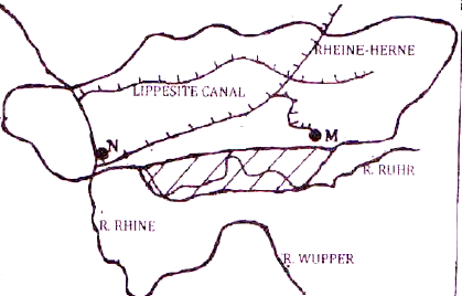 Name the towns marked M and N.
Date posted:
May 29, 2019
-
Give three reasons why hardwood tree species in Kenya are in danger of extinction
Date posted:
May 29, 2019
-
Draw a sketch map of the Great Lakes and St. Lawrence Seaway. On it mark and name the following:-
- Lakes Michigan and Ontario.
- Ports Duluth and Chicago.
Date posted:
May 29, 2019
-
Draw an outline map of Kenya.
On it mark and name the following:-
- Marsabit game reserve.
- Dodori game reserve.
- Aberdare National park.
Date posted:
May 29, 2019
-
The diagram below shows relief rainfall.
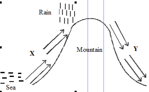 (i) Name the areas marked X and Y.
(ii) State three characteristics of the region marked Y.
(i) Name the areas marked X and Y.
(ii) State three characteristics of the region marked Y.
Date posted:
May 29, 2019
-
Name three countries where the Trans-African railway line is not completed.
Date posted:
May 29, 2019
-
The map below shows the proposed Trans-African railway and the Great North road.
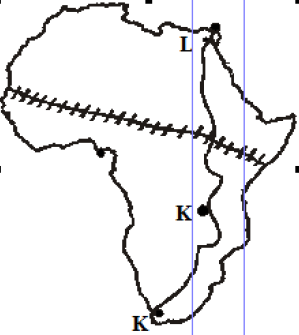 Name the towns marked J, K and L on Great North road.
Date posted:
May 29, 2019
-
State two ways in which downwash occurs.
Date posted:
May 28, 2019
-
Describe how the following lakes were formed
- Lake Masinga
- Lake Kanyaboli
Date posted:
May 28, 2019
-
Use the diagram below of a mountain vegetation zone of a mountain in Kenya to answer the following
questions.
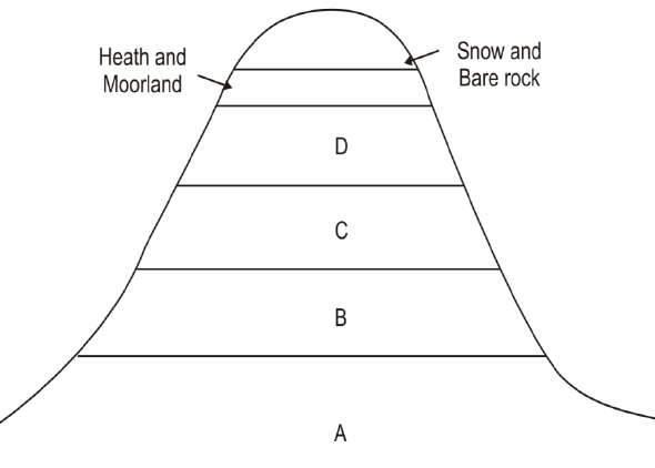 (i) Name vegetation zones A, B, C and D
(ii) Explain three importance of vegetation in zone C
(iii) What is the Government doing to ensure that vegetation in zone B is not destroyed
(i) Name vegetation zones A, B, C and D
(ii) Explain three importance of vegetation in zone C
(iii) What is the Government doing to ensure that vegetation in zone B is not destroyed
Date posted:
May 28, 2019
-
Explain how each of the following have affected Lakes in Kenya
(i) Deforestation
(ii) Industrialization
(iii) Water needs
Date posted:
May 28, 2019
-
Use the diagram below to answer the question that follows.
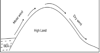 Outline the process through which moist winds shown go through to eventually become dry winds
Date posted:
May 28, 2019
-
Outline four similarities between Jua Kali industry in Kenya and cottage industry in India.
Date posted:
May 28, 2019
-
Apart from establishing national parks and game reserves, outline four ways in which wildlife is being
conserved in Kenya.
Date posted:
May 28, 2019
-
Explain three economic factors that influence population distribution in East Africa.
Date posted:
May 28, 2019
-
The table below shows the values in terms of billions US Dollars of Kenya’s import and export between the years 2003 and 2008. Use it to answer question (i) and (ii).
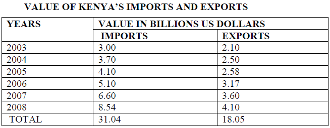 i) Calculate the balance of payment in the year 2008.
ii) Using a scale of 1 cm to represent 1 billion, draw a simple comparative bar graph based on the data above.
iii) State four reasons why Kenya’s exports are generally low.
i) Calculate the balance of payment in the year 2008.
ii) Using a scale of 1 cm to represent 1 billion, draw a simple comparative bar graph based on the data above.
iii) State four reasons why Kenya’s exports are generally low.
Date posted:
May 28, 2019
-
Distinguish between phreatic and vadose zone.
Date posted:
May 28, 2019
-
You carried out a field study on faulting in the Rift Valley of Kenya.
i) State two objectives for the study you carried out.
ii) Give three follow – up activities you may have engaged in.
Date posted:
May 28, 2019
-
With the aid of well labeled diagrams describe how a rift valley can be formed by Compressional forces.
Date posted:
May 28, 2019
-
Name two plains found in Kenya.
Date posted:
May 28, 2019
-
Define the term ‘Industrial Conurbation.’
Date posted:
May 28, 2019
-
Differentiate between a game sanctuary and an animal orphanage.
Date posted:
May 28, 2019
-
Give two reasons why Gold mining in Kenya has not been fully exploited.
Date posted:
May 28, 2019
-
Outline three human factors that favour tea growing in the Nandi Hills area of Kenya.
Date posted:
May 28, 2019
-
Explain how earth’s rotation causes horizontal movement of ocean water.
Date posted:
May 28, 2019
-
Differentiate between rock slide and soil creep.
Date posted:
May 28, 2019
-
Explain the importance of studying rocks.
Date posted:
May 28, 2019
-
List two main types of rocks dominant in Kenya.
Date posted:
May 28, 2019
-
Differentiate between a weather station and a Stevenson screen.
Date posted:
May 28, 2019
-
If the local time in town A at longitude 200E is 10a.m., what will be the time at town B at longitude 100W?
Date posted:
May 28, 2019