📘 Access 10,000+ CBC Exams With Marking Schemes
Prepare your learners for success! Get CBC-aligned exams for Grades 1–9, PP1–PP2, Playgroup and High School - all with marking schemes.
Browse Exams
Instant download • Trusted by 100,000+ teachers • Updated weekly
Form 4 Geography Paper 1 Term 2: 312/1 With Answers Question Paper
Form 4 Geography Paper 1 Term 2: 312/1 With Answers
Course:Geography
Institution: Form 4 question papers
Exam Year:2016
KENYA CERTIFICATE OF SECONDARY EDUCATION 2016
312/1
GEOGRAPHY
PAPER 1
2 hours 45 minutes
Instructions to candidates
This paper has TWO sections A, and B
Answer All questions in sections A in section B answer question six and any other two questions
SECTION A
1. (a) Name the three transitional zones of the atmosphere
(3 marks)
(b) Give two reasons why cloud concentration is higher in the troposphere
(2 marks)
2. (a) State three sources of underground water
(3 marks)
(b) State two ways in which underground water may reach the surface of the earth
(2 marks)
3. (a) What are the conditions for occurrence of saline lakes in rift valley
(3 marks)
(b) State two ways in which lakes are formed naturally
(2 marks)
4. (a) Apart from secondary waves name two other types of waves generated by an earth quake
(2 marks)
(b) (i) State two characteristic of S waves generated by an earthquakes
(2 marks)
(ii) Name the instrument that measures seismic waves
(1 mark)
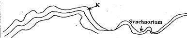
5. (a) The diagram below shows a folder region name the feature marked K.
(1 mark)
(b) (i) Name any two fold mountains in the word outside the continent of Africa and identify the continent(s) where they are found.
(2 marks)
(ii) What is temperature inversion
(2 marks)
SECTION B
Answer question 6 any other two questions in this section
You are provided with the map of Busian (1:50,000). Use it to answer the questions that follow.
6. (a) (i) Identify three man – made features in grid square 2536
(3 marks)
(ii) Identify the longitudinal extent of the map
(1 mark)
(b) (i) Give the sheet number of Busia map
(1 mark)
(ii) Measure the length of the all weather Road Loose Surface from the Eastern margin of the map up to the first junction
(2 marks)
(c) (i) Using a scale of 1 cm represents 20 m, draw a cross section along northing 35 between easting 27 and 32.
(3 marks)
(ii) On your section mark and show the following:
- River Kawuoda
(1 marks)
- Footpath
- A hill
(1 mark)
(iii) Calculate the vertical exaggeration of the cross – section
(2 marks)
(d) State six characteristics of relief in the area covered by the map
(6 marks)
(e) Students of Strathmore School carried out a field study in the area covered by map.
(i) Identify two data collection methods they used during the field study
(2 marks)
(ii) State two follow up activities they carried out after the field study
(2 marks)
7. (a) What is plant community?
(1 mark)
(b) Explain three factors that have led to a decline of natural grassland in Kenya.
(6 marks)
(c) Use the map of Kenya below and answer questions that follow.
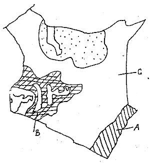
(i) Name the vegetation type marked A, B, and C
(3 marks)
(ii) State six characteristics of vegetation type labeled B
(6 marks)
(d) You carried a field study on vegetation in your district
(i) Why was it necessary for you to conduct a reconnaissance?
(2 marks)
(ii) Name three methods you used in recording data
(3 marks)
(iii) Name two tree species you identified during the field study
(2 marks)
(iv) Name two types of maps you used in recording your findings
(2 marks)
8. (a) Differentiate between aridity and desertification
(2 marks)
(b) Name three types of desert surfaces
(3 marks)
(c) Using well labeled diagrams explain the formation of the following desert features
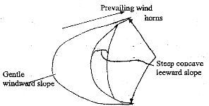
(i) Barchan
(3 marks)
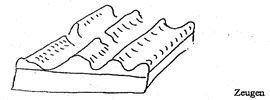
(ii) Zeugens
(3 marks)
d) (i) Explain the role played by ocean currents in enhancing aridity
(4 marks)
(ii) Give three examples of ocean currents and name the arid areas that result from their influence
(3 marks)
(e) (i) Name three processes involved in wind erosion in deserts
(3 marks)
(ii) What is the significance of desert features to man
(4 marks)
9. (a) Give four characteristics of desert soil
(4 marks)
(b) How does elluviation contribute to soil degeneration.
(4 marks)
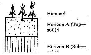
(c) Draw a well labeled diagram of a mature soil profile
(5 marks)
(d) Explain four ways in which human activities contribute to soil degeneration
(4 marks)
(e) Students in a school in Baringo district carried out a field study on soil erosion in the district
(i) How will their finding benefit the farmer/ residents of the district
(6 marks)
(ii) Give two methods they used to pass the information to the farmers
(2 marks)
10. Explain how each of the following lakes were formed.
(9 marks)
(i) Lake Victoria
(ii) Lake Sare
(iii) Lake Nasser.
(b) State the difference between the lakes on the Eastern and Western areas of the Eastern Africa Rift Valley.
(6 marks)
(c) Explain any five significance of lakes
(10 marks)
Marking Scheme/Answers
KENYA CERTIFICATE OF SECONDARY EDUCATION 2016
GEOGRAPHY PAPER 1 – (312/1)
MARKING SCHEME
SECTION A
1. a) Three transitional zones of the atmosphere.
- Tropopause
- Stratopause
- Mesopause
- Thermopause
b) Two reasons why cloud concentrations is higher in the Troposphere
- Temperature decrease with increase is height.
- Presence of particles in the layer like dust. Act as condensation nuclei
- Has high humidity (water vapour)
2. Three sources of underground water
a) Rain water
- Magmatic water
- Snow and ice melt water
- water bodies like seas, rivers, swamps
b) Two ways in which underground water reaches the surface of the earth
- Springs
- Capillary action
- Wells and boreholes/artesian wells
-See page
- Transpiration
3.a) Conditions for the occurrence of saline lakes in the Rift valley.
Absence of outlets
- Absence of strong winds to remove the salt from the lakes beds which later dry up.
- Lack of constant inflow of fresh water
- presence of intense saline springs feeding the lakes.
- Lack of seepage of salt and water from the lakes (underground outlets/ drainage)
- Volcanic action results to magma releasing salts
- High rates of evaporation
- Underlying salt rock(Imbedded)
b) State two ways lakes form naturally
- Earth movements e,g down warping and tectonic processes
- Volcanicity eg lava damming, caldera/crater/maars.
- Erosion e.g glacial, solution, wild
- Deposition, E,g River deposits (Glacial deposits, marine deposits)
- mass movement
-Meteorite crater lakes
4, Two other waves apart from secondary waves
a) Long – Waves – L waves , longitudes/ waves/ ray leigh waves/ love waves
p- waves – primary waves
Characteristics of S – waves
b) i) – Are the second to be recorded on the seismograph.
- Are shake and shear waves
- Pass through solid only
- Are very strong waves
- They travel at a speed of about 4.5 km/sec
- Causes vibrations perpendicular to their path
ii) Instrument that measure seismic waves.
Seismograph
5. a) i) K – Anticlinorium’s
ii) Two fold matins outside Africa – Andes, Himalayas, Rockies, Alps, and Appalachians
iii) Temperature inversion is the increase in temperature with increase in altitude
Section B
You are provided with the map of Busia(1:50,000) use it to answer the questions that follow
6.a) i) Identify three man – made features in grid square 2536
- All weather road loose surface (do not accept “road”)
- Air photo principal point
- Main track (Motorable)
- Settlements/huts
ii) Identify the longitudinal extent of the map
34o05 to 35o15 East(direction must be given)
b) i) Give the sheet number of Busia map
101/1
ii) Measure the length of the All Weather Road Loose Surface from the Eastern margin of the map up to the first junction
. 6.3 km (+ or -0.1)
c) i) Using a scale of 1cm represents 20m, draw a cross section along northing 35 between easting 27 and 32.
(ii) On your cross section mark and show the following:
. River Kawuoda
. Footpath
. A hill
(iii) Calculate the vertical exaggeration of the cross – section
- V.E = vertical scale/ horizontal scale
= 1: 2000/ 1: 50000
= X25 (do not accept 25)
d) State six characteristics of relief in the area covered by the map
- There are several Hills in the southern part of the area covered by the map as shown by circular contour lines.
- There are passes e,g along Easting 30 shown by a footpath in between two adjacent hill/ raised section of land.
- There are steel slopes towards the south of Busia as shown by closely packed contour lines.
- Most parts of Busia are gently sloping as shown by widely spaced contour lines e.g in the west.
- The hills towards the south of the area form a ridge as they are aligned in a linear pattern
- The land generally rises towards the south as shown by low contours like 1180m in the north and 1300m in the south.
- There are several cols/saddles in the central and southern area as shown by several adjacent hills without any passage way between.
(e)Students of Strathmore School carried out a field study in the area covered by the map.
(i) Identify two data collection methods they used during the field study
- Photography
- Interviewing
- Observation
- Sampling
- Experimentation
- Counting (Check any other relevant answers)
(ii) State two follow up activities they carried out after the field study
_ Displaying and analyzing any of the photographs taken during the fieldwork
- Labeling of various samples taken during the study
- Drawing of graphs, pie charts and other statistical information
- Analyzing the data collected in groups
- Class discussions on findings
- Report writing
- Laboratory testing of samples
- Displaying collected samples
- Listening to tape records, watching video tapes
(check other relevant answers)
6. a) Plant community is an assemblage of plants that grow together in a particular habitat/ site.
Or
Plants such as trees, herbs and grasses that grow in a given place and give it a distinct character.
b) Explain factors for the decline of natural vegetation
- Population increase – encroaching into the grassland replacing it with settlements and cultivated land.
= Frequent outbreaks of bush fires that destroys the grasses retarding its generation
- Pests e.g armyworms/ locust destroy grass and the vegetation regenerates into semi – desert type.
- Wild and domesticated animals overgraze and causes stunted growth of grass.
Note – The candidates must state and explain its score 2 marks
c) Identify the vegetation A, B, and C
i) A – Equation forests
B – Savanna grasslands
C – Semi – Arid vegetation
ii) Characteristics of savanna veg.
- Consists of a mixture of trees and grass
- In the wetter areas grasses are tall and closer to each other
- Grasses dominate the undergrowth in the woodlands
- Trees are umbrella shaped
- Trees are shorter and more scattered
- Acacia trees dominate
- Some trees are stunted and have scale, trunks/ barks
- River valleys have trees and thick bush
- Grass wither during dry season
- Grass sprouts during wet season
- Shrubs/ trees are deep rooted
- Grasses are shorter in drier areas
- Trees like Baobab have thick barks (succulent)
d) I) Reasons for reconnaissance
- Prepare a work schedule
- familiarize with the area and respondents
- Introduce oneself to the authority and respondents.
- Determine the suitability of the area for study
- Identify and decide on the method and tools for data collection.
- Estimate the cost for the study.
- Determined the route to follow(suitable)
- Identify the problems they are likely to encounter.
ii) Three methods used in recording data.
- Labeling samples
- Note taking
- Tabulation
- Photographing
- Filling questionnaires
- Field sketching
iii) Two tree species identified during the field study
- Acacia, cedar, Meru, Oak, Elgon teak, Blue gums, Cyprus pine, black wattle etc
Accept any tree stated
iv) Two types of maps used in recording findings
- Density/ choropleth, maps/layer tinting/coloring
- Distribution maps
- Sketch maps
- Dot maps
7. a) Differentiate aridity and desertification
Aridity – A state of dryness/ deficiency of rainfall or no rainfall.
- Desertification – encroachment of large areas of barren land which are covered with sand.
- The slow but steady encroachment of desert like conditions onto potentially or formerly productive land
b) types of desert surfaces
- Sand deserts
- Stony deserts
- Rock deserts
c) i) Barchan
- Crescent – shaped heaps of sand
- Lie at right angles to prevailing winds
- Starts as a build up of sand behind a low obstacles like rock/ bush.
- The mound grows bigger and bigger, its edges are slowly carried forward by the wind.
- This gives it a crescent shape. Side away from the wind is steep – eddies make it more steeper (Leeward)
- Windward side forms a smooth gentle sand dome slope.
ii) Zeugens
- Produced by the action of weathering and wind
- Weathering breaks the hard cap
- Weathering materials are then worked on by wind abrasion as they are transported, they knock on the rock mass, and scour through differential erosion.
- It forms ridges and furrows if it continues.
D) i) Influence of Ocean currents on deserts
- Cold Ocean currents blowing along coastal regions bring cold conditions
- Cold conditions lead to the formation of fog and mist
- Ground and air along such areas is not heated hence no Turbulence
- Winds also carry no moisture hence they are dry
- Winds drop their moisture over, the sea – reaching the land as dry winds
ii) Oceans currents and the areas they cause aridity.
- Benguela current – Namib and Kalahari desert
- Peruvian current - Atacama desert
- California current – California desert
- Canaries current – Sahara desert
- Antartic current – Australian desert
Candidates must mention/ state the current and the desert region for them to score.
e) i) Abrasionn
- Attrition
- Deflation
ii) Tourist attraction e.g yardang, zeugens, Barchans etc.
- Hold desert sun provide a large potential for solar energy.
- Basins/ blow outs hold permanent lakes which may give rise to oases providing permant sources of water.
- Water from the oases is used for irrigation, domestic and industrial purposes
- Desert landforms are ideal for military training testing of weapons and experimenting ground loes form fertile alluvium soils.
- Sand dune migration may destroy huge tracks of agriculture land/ threaten human and animals life
8. Characteristics of desert soils.
a) – thin and shallow
- Sand and stony
- salty
- Have low organic matter
- Are loose and unconsolidated
- Have high lime content/ alkaline / rich in calcium.
- Have low moisture content
- Are brownish/ reddish in colour candidates must explain the factor
b) Elluviation/ degeneration
- Leaches weathered materials(mineral salts) from Horizon A to B and C
- Makes minerals salts unavailable to plant roots
- Leads to change in soil texture and structure
- Change soil colour
- Reduces humus content/ hence leads to poor water retention capacity
- soil becomes loose - hence exposed to soil erosion agents.
Ways through human beings contribute to soil degeneration
c)- monoculture farming activities lead to soil exhaustion this making soil vulnerable to erosion
- Overgrazing reduces vegetation cover exposing soil to agents of erosions.
- Ploughing up/ down a slope provides channels for surface run off. These are enlarged to become gullies
- Deforestation/ clearing of vegetation cover over exposes soil to agents of soil erosion
- Mining/ quarry/ road construction loosens, exposes the soil making of it susceptible to erosion
- Continues cultivation without replenishment of soil fertility leads to soil exhaustion making the soil vulnerable to erosion
- Shifting cultivation without replenishment of soil fertility leads to soil exhaustion making the soil vulnerable to erosion
- Shifting cultivation/ bush fallowing leaves land unprotected against erosion
d) Findings
- Overstocking – Farmers to reduce the number of livestock
- Deforestation - Plant more trees/ reafforestation
- Ploughing on steep slopes – contour ploughing
- Monoculture – diversification of crops
- Soil erosion – plant cover crops
Benefits
Quality animals/ more milk/ quality beef
- Improved soil fertility – Better crop yields
- Improvement of water catchment areas
- Improvement of biodiversity
- Environmental improvement
For the candidates to score should identify a problem and provide a solution.
e) Barazas – chief/ D.os
- radios
-Newspapers
- Circulars etc
9. Formation of lake Victoria
- Earth movements caused by Compression forces acted on the land between Kenya and Uganda
- The central part then down warped to form a depression / basin
- This was followed by uplifting/ Tilting of the surrounding landmasses in Kenya to form the Mau Ranges
- On the Ugandan side, Uplifting took place leading to the formation of the Ruwenzori’s mountains
- Reversed drainage/back tilting took place on Uganda rivers like Kagera, Katonga forcing them into the depression
- Deposition into the depression resulted into further down warping
- Water from rain, seepage and the rivers accumulated in the basin forming lake Victoria.
ii) Lake Sare- Formed as result of long shore drift/ causing continuous deposition/hence a spit encloses a shallow lagoon/ at ugowe Bay L. Victoria
iii) Lake Nasser – Is a manmade lake , Depression is dug first a river is diverted and water fills depression
b) – Eastern generally alkaline while western generally fresh
- Eastern have no outlets except Naivasha & Baringo while Western have outlets
- Eastern generally wide and deep while western are long and deep
c) – Source of fish e,g Victoria, Turkana
- H.E.P Production e,g Owen falls, L. Victoria
- Transport e,g L. Victoria
- Sources of rivers eg L. Victoria is source of R. Nile
- Tourist attraction e,g L. Nakuru, Elementaita.
- Irrigation purposes e,g Naivasha
- Source of minerals e,g L. Magadi
- Building material e.g Sand from L. Victoria
Points must be well explained with specific examples and the economic aspect must come out clearly = 10 marks
More Question Papers
Exams With Marking Schemes
End Term 3 Exams
Mid Term Exams
End Term 1 Exams
Opener Exams
Full Set Exams
Return to Question Papers